1. Lake Hillier, Australia
 |
| link |
Lake Hillier, is a lake on Middle Island, the largest of the islands and islets that make up the Recherche Archipelago, Western Australia. It is the most prominent lacustrine feature on any island of the archipelago and air passengers often take note of it.
The specialty of this lake is its flamboyant colour, rose pink. The colour is permanent, as it does not alter when the water is taken in a container. The length of the lake is about 600 m (1970 ft). A narrow strip of land composed of sand dunes covered by vegetation separates it from the ocean.
The lake is surrounded by a rime of white salt and a dense woodland of Paperbark and Eucalypt trees with sand dunes separating the lake from the Southern Ocean to the north. Middle Island and lake were discovered in 1812. [link, map]
2. Lake Retba, Senegal
Lake Retba or Lac Rose lies north of the Cap Vert peninsula of Senegal, north east of Dakar. It is so named for its pink waters, caused by Dunaliella salina algae in the water.
The color is particularly visible during the dry season. The lake is also known for its high salt content, which, like that of the Dead Sea, allows people to float easily.
The lake also has a small salt collecting industry. Many salt collectors work 6–7 hours a day in the lake, which has a salt content close to 40%.
In order to protect their skin, they rub their skin with "Beurre de Karité" (shea butter, produced from shea nuts obtained from the Shea nut tree), which is an emollient used to avoid tissue damage. [link, map]
3. Salina de Torrevieja, Spain
Salina de Torrevieja and La Salina de La Mata are salt lakes that surrounds Torrevieja - a seaside city in south-eastern Spain. The microclimate formed by La Salina de Torrevieja and La Salina de La Mata, both the biggest saltlakes in Europe, is declared one of the healthiest of Europe by the WHO - World Health Organisation.
Because of the algae and salt quantity Salina de Torrevieja lake looks pink, which gives it a 'sciencefiction' view. Just like the Dead Sea in Israel, you can float on this lake too. Also, it is very healthy for the skin and lungdiseases.
The salt dug from this lake by the factories at the other end is exported to many countries. This lake attracts a large number of bird species. [link1, link2, map]
4. Hutt Lagoon, Australia
Hutt Lagoon is a salt lake located near the coast just north of the mouth of the Hutt River, in midwest Western Australia. This body of water is an elongate lake that sits in a dune swale adjacent to the coast.
The town of Gregory is located between the ocean and the lake's southern shores. The road between Northampton and Kalbarri, George Grey Drive, runs along its western edge.
The lake is about 14 km (8.7 mi) in length along its long axis which is oriented in a northwest-southest direction, parallel with the coast. It is around 2 km (1.2 mi) wide.
 |
| link |
 |
| link |
2. Lake Retba, Senegal
 |
| link |
 |
| link |
 |
| An aerial shot of salt piled up along the shoreline of Lake Retba link |
 |
| link |
3. Salina de Torrevieja, Spain
 |
| Aerial view of the Salina de Torrevieja from the Mediterranean Sea link |
 |
| link |
 |
| link |
4. Hutt Lagoon, Australia
 |
| Hutt Lagoon on the left and Indian Ocean on the right side link |
 |
| link |
 |
| link |
source Fascinating Pink Lakes, Nice n Funny
 |
| link |
5. Dusty Rose Lake, Canada
 |
| link |
6. Pink Lake, Australia
 |
| link |
 |
| link |
7. Masazirgol, Azerbaijan
 |
| link |
 |
| Workers shoveling salt into horse drawn carts link |
8. Quairading Pink Lake, Australia
 |
| link |
 |
| link |
Bonus: Field of Pink Lakes, Australia
 |
| link |
 |
| link |
source
http://www.nicenfunny.com
Largest Deserts In The World
A desert is a landscape or region that receives an extremely low amount of precipitation, less than enough to support growth of most plants. Deserts cover about one fifth (20 percent) of the earth's land area. Deserts may contain great amounts of mineral resources over their entire surface.
10. Great Basin Desert

Type:- Cold Winter
Area:- 492,000 km²
Great Basin is a cold desert bioregion represented by a small section in the NE corner of Kern County. The Great Basin Desert is an area of nearctic high deserts. The Great Basin Desert exists because of the "rainshadow effect" created by the Sierra Nevada Mountains of eastern California. Typically Great Basin Desert experiences a long, cold winter and a significant proportion of its precipitation falls as snow. This desert is one of the several communities comprising Merriam's Upper Sonoran Life Zone.
9. Syrian Desert

Type:- Subtropical
Area:- 520,000 km²
The Syrian Desert is a combination of steppe and true desert that is located in the northern Arabian Peninsula receiving on the average less than 5 inches (125 mm) of rainfall annually. The south central part of the desert is called Al Hamad. In the north it is bounded by the region known as the Fertile Crescent. The desert was historically inhabited by bedouin tribes, and many tribes still remain in the region, their members living mainly in towns and settlements built near oases. Some bedouin still maintain their traditional way of life in the desert.
8. Great Victoria Desert

Type:- Subtropical
Area:- 647,000 km²
The Great Victoria is the largest Australian desert. A vast, sparsely populated region covered by dunefields and gibber plains, the Great Victoria Desert receives little rain and experiences extreme temperatures. The vast Great Victoria Desert extends from the Eastern Goldfields area in Western Australia across the southern parts of central Australia to the Stuart and Gawler Ranges in South Australia. The climate is arid, with mean annual rainfall ranging from below 150 millimeters (mm) to over 250 mm.
7. Patagonian Desert

Type:-Cold Winter
Area:- 670,000 km²
Patagonian Desert is located primarily in Argentina with small parts in Chile and is bounded by the Andes, to its west, and the Atlantic Ocean to its east, in the region of Patagonia, southern Argentina. If you take a walk through the Patagonian desert you will spot several types of plant life from simple daisies to exotic flowers, such as the Patagonian fire bush. The desert has hosted various indigenous peoples in its past, as evidenced by cave paintings in the area. The area is sparsely populated today and those that do live here survive mainly by the raising of livestock such as sheep and goats.
6. Kalahari Desert

Type:- Subtropical
Area:- 900,000 km²
The Kalahari Desert is a large arid to semi-arid sandy area in Southern Africa extending 900,000 square kilometres (350,000 sq mi), covering much of Botswana and parts of Namibia and South Africa. The Kalahari, covered largely by reddish sand, lies between the Orange and Zambezi rivers and is studded with dry lake beds. Only in recent geological history, 10 to 20,000 years ago, were the dunes stabilised through vegetation, so the area should actually be called a dry savannah. Unlike the dunes of the Namib Desert, those of the Kalahari are stable and not wandering.
5. Gobi Desert

Type:- Cold Winter
Area:- 1,300,000 km²
The Gobi is a large desert region in Asia. It covers parts of northern and northwestern China, and of southern Mongolia. Temperatures can fall as far minus-40 degrees Fahrenheit in the winter. During Summers the heat occasionally rises to 122 degrees Fahrenheit. Unlike the Sahara there are few sand dunes in the Gobi; rather you'll find large barren expenses of gravel plains and rocky outcrops. t contains the last remaining wild Bacterian (two-humped) camels, wild ass, and a small population of Gobi bears, the only desert-inhabiting bear.
4. Arabian Desert

Type:- Subtropical
Area:- 2,330,000 km²
The Arabian Desert encompasses almost the entire Arabian Peninsula, blanketing the area in sandy terrain and seasonal winds. The Arabian Desert is a vast desert wilderness stretching from Yemen to the Persian Gulf and Oman to Jordan and Iraq. The Arabian Desert is hyper arid with average rainfall of about 1.38 inches per annum. Temperatures range from 104° to 122° Fahrenheit in the summer, to an average temperature of 41° to 59° Fahrenheit in the winter.
3. Sahara

Type:- Subtropical
Area:- 9 100,000+ km²
The Sahara is the world's largest hot desert. The word "Sahara" means "desert" in the Arabic language. Due to the massive size of the Sahara, Africa is split into two regions: that which lies above or forms part of the Sahara and the rest of Africa south of the Sahara. On the west, the Sahara is bordered by the Atlantic Ocean and on the east by the Red Sea, and to the north are the Atlas Mountains and Mediterranean Sea. Some of the sand dunes can reach 180 metres (590 ft) in height.
2. Arctic

Type:- Polar
Area:- 13,700,000+ km²
The Arctic Basin is one of the driest parts of the Arctic. Most of the Basin receives less than 250 mm of precipitation per year, qualifying it as a desert. Imagine yourself standing on some of the northern-most reaches of land in the world. During most of the year your feet would most likely be resting on ice and snow, and if you turned around in a circle, ice and snow are probably all that you would see. But this land is not lifeless. The Arctic Desert ecoregion is home to several hardy species of birds and mammals.
1. Antarctic Desert

Type:- Polar
Area:- 13,829,430 km²
Antarctica is Earth's southernmost continent, at the South Pole. It is situated in the Antarctic region of the southern hemisphere, almost entirely south of the Antarctic Circle, and is surrounded by the Southern Ocean. The nearest other land masses are South America 600 mls / 1000 km. In the winter Antarctica doubles in size due to the sea ice that forms around the coasts. The true boundary of Antarctica is not the coastline of the continent itself or the outlying islands, but the Antarctic Convergence. Enough said.
source
http://www.nicenfunny.com
Gippsland Lake Glows in the Dark
Swimming is supposed to give you a healthy glow, but these swimmers were not quite sure what was going on when they took a late-night dip and turned a fluorescent shade of blue. "It was like we were playing with radioactive paint", said photographer Phil Hart who snapped the bizarre sight as his friends emerged from a lake in the dark of night.
The light is created by a chemical reaction called bioluminescence, which happens when a naturally-occuring micro-organism in the water is disturbed. These images are particularly stunning because the concentration of the micro-organism Noctiluca Scintillans was abnormally high when he took the photos at Gippsland Lakes in Victoria, Australia.

The light is created by a chemical reaction called bioluminescence, which happens when a naturally-occuring micro-organism in the water is disturbed. These images are particularly stunning because the concentration of the micro-organism Noctiluca Scintillans was abnormally high when he took the photos at Gippsland Lakes in Victoria, Australia.

Phil, 34, put his camera on a very slow shutter speed and threw sand and stones into the water to cause the reaction and capture as much of the blue haze as possible.

It is believed the combination of bushfires and floods created the high levels of nutrients in the lakes for the organisms to feed.


source
http://www.nicenfunny.com/
Very Nice Examples Of Long Exposure Photography
1. Rush hour Star by Praveller B.S

2. Attack of the Clone Stamp Tool by Miles Morgan

3. Storming into Sunset by Danilo Faria

4. Cerdà Square at Night by Sergio Otero

5. Sky of the Night. by Abhishek Patel

6. Light driver by Peter Majkut

7. Coliseum, past and future ! by Beboy Photographies

8. Dark Parts 6 by Stefan Wolf

9. Las Vegas Light! by Nhut Pham


11. the junction by Kevin Gu

12. Lombard Street at Night by Anakin Yang


2. Attack of the Clone Stamp Tool by Miles Morgan

3. Storming into Sunset by Danilo Faria

4. Cerdà Square at Night by Sergio Otero

5. Sky of the Night. by Abhishek Patel

6. Light driver by Peter Majkut

7. Coliseum, past and future ! by Beboy Photographies

8. Dark Parts 6 by Stefan Wolf

9. Las Vegas Light! by Nhut Pham

10. U-turn by Andy Kennelly

11. the junction by Kevin Gu

12. Lombard Street at Night by Anakin Yang

source Very Nice Examples Of Long Exposure Photography, Nice n Funny
13. Subway Light by Michael Woloszynowicz

14. Rubber and line symmetry by Todd Wall

15.Light Painting by Eric Rousset

16. breakdance baby! by Joanna Jaskólska

17. Japan Memories by OaKy Isra

18. Night Rider by Liban Yusuf

19. Paris's lighthouse by Damien Bapst

20. Curvy Road by Chris Riesta

21. Carnival Lights by Bill Church

22. Me and Downtown Los Angeles at Night! by Nhut Pham

23. A good photographer captures the subject; but a good subject captures the photographer!!! by Jay Sabapathy

24. Winter rain by Todd Wall

25. Walking inside the Fire Whirlpool by Anish Adhikari

26. The Light Show by Justin Dong

27. Paris La Defense by Erwan Alliaume

28. BB from Embarcadero!!! by Jay Sabapathy

29. kıvılcım 2 by ömer yücel

30. FishEye by Mohammed Al-Jawi

31. tHe LiGht PaTh by Karim Nafatni

32. Night Road by Mikko Lagerstedt

33. San Francisco Skyline by Raveesh Ahuja

34. London Iris by Romain Matteï Photography

35. LA Financial District by Neil Kremer

source http://www.nicenfunny.com

The permanent lava lake of the Nyiragongo is the biggest in the world, an estimated 282 million cubic feet of lava. In 1977 and 2002, the lava lake breached the crater, destroying a large part of the city of Goma in the Democratic Republic of Congo.

At the surface of the lake, bubbles of gas explode. The surface is permanently churned by fury from the earth's crust.

Even though the lava lake often overflows, the seven members of the expedition yearn to walk its shores.

Mount Nyiragongo is the most active of the eight volcanoes forming the Virunga range.
source Largest Lava Lake in The World - Nyiragongo Crater, Nice n Funny
At the beginning of the descent to the second terrace, falling rocks are a major risk. The gas often blinds the climbers.

The expedition members need to tote a total of 1,300 pounds of equipment, food, and water -- enough for two days. The base camp is set up about 400 feet above the lava lake.

To prepare for the expedition, members have undergone four months of training.

Jacques Barthelemy, a mountaineer and veteran of Nyiragongo, uses a rope to bring bags of equipment to the second terrace.

Volcanic gases heat the base camp. Members often need to don gas masks for sleeping.

At night, the base camp is illuminated by the light of the lava lake.

The goal of the expedition is to reach the rim of the lava lake. Nobody has previously survived such an encounter.

Using a laser telemeter, a member measures the changing size of the lava lake.

Marc Caillet is the first member of the team to reach the lakes rim.

A major risk is the frequent overflows of the lake. Members surveying the lake from the second terrace help alert others to any threatening lava movements.

The Largest Lake On An Island In A Lake On An Island
source The Largest Lake On An Island In A Lake On An Island, Nice n Funny
Largest Island
Greenland (DEN)
Largest lake
Caspian Sea (RUS/KAZ/AZE/TKM/IRN)
Largest lake on an island
Nettilling Lake on Baffin Island (CAN)
Largest island in a lake
Manitoulin Island in Lake Huron (CAN)
Largest island in a lake on an island
Pulau Samosir in Danau Toba on Sumatera (INA)
Largest lake on an island in a lake
Lake Manitou on Manitoulin Island in Lake Huron (CAN)
Greenland (DEN)

Largest lake
Caspian Sea (RUS/KAZ/AZE/TKM/IRN)

Largest lake on an island
Nettilling Lake on Baffin Island (CAN)

Largest island in a lake
Manitoulin Island in Lake Huron (CAN)

Largest island in a lake on an island
Pulau Samosir in Danau Toba on Sumatera (INA)

Largest lake on an island in a lake
Lake Manitou on Manitoulin Island in Lake Huron (CAN)

source The Largest Lake On An Island In A Lake On An Island, Nice n Funny
...
Largest lake on an island in a lake on an island
Crater Lake on Vulcano Island in Lake Taal on Luzon (PHI)

Largest island in a lake on an island in a lake
Island in Mindemoya Lake on Manitoulin Island in Lake Huron (CAN)

Largest island in a lake on an island in a lake on an island
http://www.nicenfunny.com/
World's Top 8 Secluded Travel Destinations
It is ironic how the most dangerous places to visit are the most beautiful and serene. What then makes them to be unique and stand out? The reason is that they are secluded from the rest of the world. They provide the best that nature has to offer. Due to their limited exploration by human activities, they have inadequate social amenities. This makes them the best to explore and have an experience of a lifetime. There are places on earth that have little or no life. They are in the process of being discovered. A visit to these places gives you a different view of life away from the real world. In that case there are some of the World's Top 8 Secluded Travel Destinations in the world.
1. The Deception Island in the Antarctica :-
 |
| Penguins on Deception Island, Antarctica (Photo credit: Wikipedia) |
This island was formed as a result of volcanic eruption. It is regarded as one of the furthest spots on earth. The name deception does not relate to the nature of the island as it is regarded as one of the safest harbors on the land.
2. The private Islands of Maldives
 |
| Anantara Kihavah Villas, Maldives (Photo credit: faiyufoto) |
They are featured by a great sea of desert islands that offer travelers with an experience like never before. A travel to this secluded destination will open up to white sands, a handful of trees and the sky.
 |
| Beachscape - Southern Coast, Sri Lanka (Photo credit: whl.travel) |
This place will give you the solitude one would need for a peaceful vacation. It is a small town situated at the side of the Indian Ocean . It is a safe haven to relax and meditate on what nature has to offer.
4. The Easter Island :-
 |
| Moai at Rano Raraku, Easter Island (Photo credit:Wikipedia) |
This island is home to almost 900 statues that offer the beauty of the island. The national park of Rapa Nui
5. The Monasteries of Ladakh in India
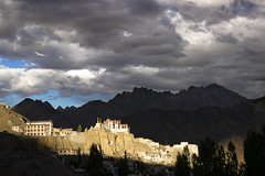 |
| Lamayuru Monastery, Ladakh, India (Photo credit: Nilanjan Sasmal) |
When you talk about seclusion, what come into mind are places away from the city. However the Monasteries of Ladakh are isolated towns which are mostly inhabited by the monks. It is the modern day ghost town as it is characterized by the ruins and scarcity of people. This is as a result of the poor climate that led to people deserting the town. A visit to this place will provide you with a different version of a modern town.
6. The Upolu island of Samoa
 |
| English: Beach view on Upolu Island, Samoa, 2009 Русский: Пляж на острове Уполу, Самоа, 2009 Gagana Samoa: Le matafaga i Upolu, Samoa, 2009 (Photo credit: Wikipedia) |
This place has much to offer in terms of the thick jungle. A walk into the jungle provides a silent and a peaceful mood. All you hear is the sound produced by the waterfalls, the birds and the whistling of the leaves. The green valleys provide the heavenly touch. A visit to this place will help you discover your sense of belonging and appreciate nature to a great extent.
7. The Mongolia
 |
| (En): In mongolia (Gobi desert) (Fr): En mongolie (Désert de Gobi) (Photo credit: Wikipedia) |
8. The Falkland Island
 |
| English: Fire Hydrant at Stanley - Falkland Islands Français : Hydrant à Stanley aux îles Malouines (Photo credit: Wikipedia) |
Although it has a population of about 3,000 you will find some alone time in the island. This is especially experienced on the outer islands of the Falkland Island
source World's Top 8 Secluded Travel Destinations, Nice n Funny
Amazing Abandoned Islands Where Time Has Stopped
1. Hirta, Scotland, UK
 |
| Abandoned village on the island of Hirta (in the picture can be seen a few renovated houses used by scientists) link |
Hirta is the largest island in the St Kilda archipelago, on the western edge of Scotland. This island may have been permanently inhabited for at least two millennia, the population probably never exceeding 180 (and certainly no more than 100 after 1851). The entire population was evacuated from Hirta in 1930, due to disease and outside influences.
 |
| Street in the abandoned village link |
Currently, temporary residents of this island are defence personnel, conservation workers, volunteers and scientists who spend time here during the summer months. [link, map]
2. Holland Island, Maryland, USA
2. Holland Island, Maryland, USA
 |
| Island in 2008 link |
Holland Island is a marshy, rapidly-eroding island in the Chesapeake Bay, in Dorchester County, Maryland, west of Salisbury. The island was once inhabited by watermen and farmers, but has since been abandoned.
 |
| The last house on Holland Island in May 2010. This house fell into the bay in October 2010 link |
By 1910, the island had about 360 residents, making it one of the largest inhabited islands in the Chesapeake Bay. The wind and tide began to seriously erode the west side of the island, where most of the houses were located, in 1914. This forced the inhabitants to move to the mainland. [link, map]
3. North Brother Island, New York, USA
3. North Brother Island, New York, USA
.jpg) |
| Skeletons of abandoned Buildings and Docks on North Brother Island link |
North Brother Island is an island in the East River situated between the Bronx and Riker's Island. Its companion, South Brother Island, is a short distance away. The island was uninhabited until 1885, when Riverside Hospital moved there from Blackwell's Island (now known as Roosevelt Island). Riverside Hospital was founded in the 1850s as the Smallpox Hospital to treat and isolate victims of that disease. Its mission eventually expanded to other quarantinable diseases. The hospital was closed around 1940.
 |
| The road between the abandoned buildings link |
Now a bird sanctuary, the island is currently abandoned and off-limits to the public. Most of the original hospitals' buildings still stand, but are heavily deteriorated and in danger of collapse. A dense forest conceals the ruined hospital buildings, and from the 1980s through the early 2000s it supported one of the area's largest nesting colonies of Black-crowned Night Heron. However as of 2011 this species has abandoned the island, for unknown reasons. [link, map]
4. Bikini Atoll, Marshall Islands
4. Bikini Atoll, Marshall Islands
 |
| Welcome sign at the Enyu aristrip on Bikini Atoll, site of post-WWII nuclear bomb testing link |
Bikini Atoll is an atoll, listed as a World Heritage Site, in the Micronesian Islands of the Pacific Ocean, part of Republic of the Marshall Islands. Humans have inhabited the atoll for at least 2,000 years. Bikini was visited by only a dozen or so ships before the establishment of the German colony of the Marshall Islands in 1885.
source Amazing Abandoned Islands Where Time Has Stopped, Nice n Funny
.jpg)
Between 1946 and 1958, twenty-three nuclear devices were detonated at Bikini Atoll. The Micronesian inhabitants, who numbered about 200 before the United States relocated them because of radiation, ate fish, shellfish, bananas, and coconuts. A large majority of the Bikinians were moved to Kili Island as part of their temporary homestead, but remain there today and receive compensation from the United States government for their survival. [link, map]
5. Hashima Island, Japan
5. Hashima Island, Japan
Hashima Island, commonly called Gunkanjima, is one among 505 uninhabited islands in the Nagasaki Prefecture about 15 kilometers from Nagasaki itself. The island was populated from 1887 to 1974 as a coal mining facility. The island's most notable features are the abandoned concrete buildings and the sea wall surrounding it.
 |
| Abandoned buildings on the island of Hashima link |
The island has been administered as part of Nagasaki city since 2005; it had previously been administered by the former town of Takashima. It is known for its coal mines and their operation during the industrialization of Japan. Mitsubishi bought the island in 1890 and began the project, the aim of which was retrieving coal from undersea mines. [link, map]
6. Great Blasket Island, Ireland
6. Great Blasket Island, Ireland
 |
| Abandoned houses on Great Blasket Island link |
Great Blasket is the principal island of the Blaskets, County Kerry, Ireland. The island was inhabited until 1953, when the Irish government decided that it could no longer guarantee the safety of the remaining population. It was the home of three noted Irish writers: Tomás Ó Criomhthain, Peig Sayers and Muiris Ó Súilleabháin.
 |
| The view from the island link |
Until 1953, the inhabitants of Great Blasket Island formed the most westerly settlement in Ireland. The small fishing community (even at its peak the population was hardly more than 150) mostly lived in primitive cottages perched on the relatively sheltered north-east shore. Today, the island was abandoned and sold to the state. [link, map]
7. Stroma, Scotland, UK
7. Stroma, Scotland, UK

Stroma is an island off the northern coast of the Scottish mainland. Once populous, this uninhabited island is owned by a Caithness farmer who uses it to graze sheep. In the past Stroma had a population of about 550, which by 1901 had reduced to around 375. The population continued to decline through the 20th century, and most of the last residents left in the early 1960s to work on the construction of the Dounreay power station. The last two families left around 1962.
 |
| The school on Stroma, it is now used as a shed for shearing sheep link |
The number of ruined houses shows how well populated the island was at one time. In the centre of the island is a church with a bell tower. Next to the church is the manse which is kept habitable for use by visiting shepherds, particularly at lambing time. Stroma is now a conservation area with an area fenced off to protect the rare plants from the sheep. [link, map]
8. Great Isaac Cay, Bahamas

9. Pollepel Island, New York, USA
8. Great Isaac Cay, Bahamas

Great Isaac Cay is a small Bahamian island located about 20 miles (32 km) of the Bimini Islands. It is accessible only by boat. The most prominent feature of the island is its lighthouse, which was erected in 1859, and stands about 151 feet (46 m) tall. In 1969 the island was abandoned by the two keepers who were guarding the lighthouse and other buildings.

The grounds are open to the public, although the lighthouse itself has had stairs removed to block access to the interior of that structure. The keepers’ house, cistern, and assorted buildings are crumbling into ruins. The derelict collection of abandoned buildings make Great Isaac Cay a popular destination for boaters. [map]
9. Pollepel Island, New York, USA
.jpg) |
| link |
Pollepel Island is an island in the Hudson River. Also known as Pollopel Island and Bannerman Island, it is the site of Bannerman's Castle. This Island is about 50 miles (80 km) north of New York City and about 1,000 feet (300 m) from the Hudson River's eastern shore.
.jpg) |
| The ruins of Bannerman's castle link |
The principal feature on the island is Bannerman's Castle, an abandoned military surplus warehouse. Today, the castle is property of the New York State Office of Parks, Recreation and Historic Preservation and is mostly in ruins. While the exterior walls still stand, all the internal floors and non-structural walls have since burned down. The island has been the victim of vandalism, trespass, neglect and decay. [link, map]
source
http://www.nicenfunny.com/


