

Venice (Italian: Venezia, Venetian: Venesia) is a city in northern Italy known both for tourism and for industry, and is the capital of the region Veneto, with a population of about 272,000 (census estimate 1 January 2004). Together with Padua, the city is included in the Padua-Venice Metropolitan Area (population 1,600,000).

The name is derived from the ancient tribe of Veneti that inhabited the region in Roman times. The city historically was the capital of an independent city-state. Venice has been known as the “La Dominante”, “Serenissima”, “Queen of the Adriatic”, “City of Water”, “City of Masks”, “City of Bridges”, “The Floating City”, and “City of Canals”. Luigi Barzini, writing in The New York Times, described it as “undoubtedly the most beautiful city built by man”. Venice has also been described by the Times Online as being one of Europe’s most romantic cities.

The city stretches across 117 small islands in the marshy Venetian Lagoon along the Adriatic Sea in northeast Italy. The saltwater lagoon stretches along the shoreline between the mouths of the Po (south) and the Piave (north) Rivers. The population estimate of 272,000 inhabitants includes the population of the whole Comune of Venezia; around 60,000 in the historic city of Venice (Centro storico); 176,000 in Terraferma (the Mainland), mostly in the large frazioni of Mestre and Marghera; and 31,000 live on other islands in the lagoon.

The Republic of Venice was a major maritime power during the Middle Ages and Renaissance, and a staging area for the Crusades and the Battle of Lepanto, as well as a very important center of commerce (especially silk, grain and spice trade) and art in the 13th century up to the end of the 17th century. This made Venice a wealthy city throughout most of its history. It is also known for its several important artistic movements, especially the Renaissance period. Venice has played an important role in the history of symphonic and operatic music, and it is the birthplace of Antonio Vivaldi.

Origins
While there are no historical records that deal directly with the obscure and peripheral origins of Venice, tradition and the available evidence have led several historians to agree that the original population of Venice consisted of refugees from Roman cities near Venice such as Padua, Aquileia, Treviso, Altino and Concordia (modern Portogruaro) and from the undefended countryside, who were fleeing successive waves of Germanic invasions and Huns.
While there are no historical records that deal directly with the obscure and peripheral origins of Venice, tradition and the available evidence have led several historians to agree that the original population of Venice consisted of refugees from Roman cities near Venice such as Padua, Aquileia, Treviso, Altino and Concordia (modern Portogruaro) and from the undefended countryside, who were fleeing successive waves of Germanic invasions and Huns.
Some late Roman sources reveal the existence of fishermen on the islands in the original marshy lagoons. They were referred to as incolae lacunae (“lagoon dwellers”). The traditional founding is identified with the dedication of the first church, that of San Jacopo at the islet of Rialto (Rivoalto, “High Shore”), given a conventional date of 421.

The last and most enduring irruption in the north of the Italian peninsula, was that of the Lombards in 568, leaving the Eastern Roman Empire a small strip of coast in the current Veneto, and the main administrative and religious entities were therefore transferred to this remaining dominion, centered upon the Exarchate of Ravenna, the local representative of the Emperor in the East. The Venetian tradition of the islanders’ aid to Belisarius was reported in early histories to explain the largely theoretical link to Ravenna, and to the Eastern Emperor
New ports were built, including those at Malamocco and Torcello in the Venetian lagoon. The tribuni maiores, the earliest central standing governing committee of the islands in the Lagoon, dated from c. 568.
The Venetians traditionally having offered asylum to the Exarch, in flight from the Lombard Liutprand, the Byzantine domination of central and northern Italy was subsequently largely eliminated by the conquest of the Exarchate of Ravenna in 751 by Aistulf. During this period, the seat of the local Byzantine governor (the “duke/dux”, later “doge”) was situated in Malamocco. Settlement on the islands in the lagoon probably increased in correspond
Sometime in the first decades of the eighth century, the people of the lagoon elected their first leader Ursus, who was confirmed by Byzantium and given the titles of hypatus and dux. He was the first historical Doge of Venice.
In 775-76, the bishopric seat of Olivolo (Helipolis) was created. During the reign of duke Agnello Particiaco (811-827) the ducal seat was moved from Malamocco to the highly protected Rialto, the current location of Venice. The monastery of St. Zachary and the first ducal palace and basilica of St. Mark, as well as a walled defense (civitatis murus) between Olivolo and Rialto were subsequently built here. Winged lions which may be seen in Venice are a symbol for St. Mark.
In 775-76, the bishopric seat of Olivolo (Helipolis) was created. During the reign of duke Agnello Particiaco (811-827) the ducal seat was moved from Malamocco to the highly protected Rialto, the current location of Venice. The monastery of St. Zachary and the first ducal palace and basilica of St. Mark, as well as a walled defense (civitatis murus) between Olivolo and Rialto were subsequently built here. Winged lions which may be seen in Venice are a symbol for St. Mark.
In 810, an agreement between Charlemagne and Nicephorus recognized Venice as Byzantine territory and recognized the city’s trading rights along the Adriatic coast, where Charlemagne had previously ordered the pope to expel the Venetians from the Pentapolis. In 828, the new city’s prestige was raised by the acquisition of the claimed relics of St. Mark the Evangelist from Alexandria, which were placed in the new basilica. The patriarchal seat was also moved to Rialto. As the community continued to develop and as Byzantine power waned, it led to the growth of autonomy and eventual independence.

Expansion
From the ninth to the twelfth century Venice developed into a city state (an Italian thalassocracy or Repubblica Marinara, the other three being Genoa, Pisa, and Amalfi). Its strategic position at the head of the Adriatic made Venetian naval and commercial power almost invulnerable. With the elimination of pirates along the Dalmatian coast, the city became a flourishing trade center between Western Europe and the rest of the world (especially the Byzantine Empire and the Islamic world). In the 12th century the foundations of Venice’s power were laid: the Venetian Arsenal was under construction in 1104; the last autocratic doge, Vital II Michele, died in 1172.
From the ninth to the twelfth century Venice developed into a city state (an Italian thalassocracy or Repubblica Marinara, the other three being Genoa, Pisa, and Amalfi). Its strategic position at the head of the Adriatic made Venetian naval and commercial power almost invulnerable. With the elimination of pirates along the Dalmatian coast, the city became a flourishing trade center between Western Europe and the rest of the world (especially the Byzantine Empire and the Islamic world). In the 12th century the foundations of Venice’s power were laid: the Venetian Arsenal was under construction in 1104; the last autocratic doge, Vital II Michele, died in 1172.

The Republic of Venice seized a number of places on the eastern shores of the Adriatic before 1200, mostly for commercial reasons, because pirates based there were a menace to trade. The Doge already carried the titles of Duke of Dalmatia and Duke of Istria. Later mainland possessions, which extended across Lake Garda as far west as the Adda River, were known as the “Terraferma”, and were acquired partly as a buffer against belligerent neighbours, partly to guarantee Alpine trade routes, and partly to ensure the supply of mainland wheat, on which the city depended.

In building its maritime commercial empire, the Republic dominated the trade in salt, acquired control of most of the islands in the Aegean, including Cyprus and Crete, and became a major power-broker in the Near East. By the standards of the time, Venice’s stewardship of its mainland territories was relatively enlightened and the citizens of such towns as Bergamo, Brescia and Verona rallied to the defence of Venetian sovereignty when it was threatened by invaders.

Venice remained closely associated with Constantinople, being twice granted trading privileges in the Eastern Roman Empire, through the so called Golden Bulls or ‘chrysobulls’ in return for aiding the Eastern Empire to resist Norman and Turkish incursions. In the first chrysobull Venice acknowledged its homage to the Empire but not in the second, reflecting the decline of Byzantium and the rise of Venice’s power.

Venice became an imperial power following the Venetian-financed Fourth Crusade, which in 1204 seized and sacked Constantinople and established the Latin Empire. As a result of this conquest considerable Byzantine plunder was brought back to Venice.

This plunder included the gilt bronze horses from the Hippodrome of Constantinople which were originally placed above the entrance to St Mark’s cathedral in Venice, although the originals have been replaced with replicas and the originals are now stored within the basilica. Following the fall of Constantinople the former Roman Empire was partitioned among the Latin crusaders and the Venetians. Venice subsequently carved out a sphere of influence in the Mediterranean known as the Duchy of the Archipelago, and seized Crete.

The seizure of Constantinople would ultimately prove as decisive a factor in ending the Byzantine Empire as the loss of the Anatolian themes after Manzikert. Though the Byzantines recovered control of the ravaged city a half century later, the Byzantine Empire was greatly weakened, and existed as a ghost of its old self until Sultan Mehmet The Conqueror took the city in 1453.

Situated on the Adriatic Sea, Venice always traded with the Byzantine Empire and the Muslim world extensively. By the late thirteenth century, Venice was the most prosperous city in all of Europe. At the peak of its power and wealth, it had 36,000 sailors operating 3,300 ships, dominating Mediterranean commerce. During this time, Venice’s leading families vied with each other to build the grandest palaces and support the work of the greatest and most talented artists.

The city was governed by the Great Council, which was made up of members of the noble families of Venice. The Great Council appointed all public officials and elected a Senate of 200 to 300 individuals. Since this group was too large for efficient administration, a Council of Ten (also called the Ducal Council or the Signoria), controlled much of the administration of the city. One member of the great council was elected “Doge”, or duke, the ceremonial head of the city, who normally held the title until his death.
The Venetian governmental structure was similar in some ways to the republican system of ancient Rome, with an elected chief executive (the Doge), a senate-like assembly of nobles, and a mass of citizens with limited political power, who originally had the power to grant or withhold their approval of each newly elected Doge.
Church and various private properties were tied to military service, though there was no knight tenure within the city itself. The Cavalieri di San Marco was the only order of chivalry ever instituted in Venice, and no citizen could accept or join a foreign order without the government’s consent.

Venice remained a republic throughout its independent period and politics and the military were kept separate, except when on occasion the Doge personally headed the military. War was regarded as a continuation of commerce by other means (hence, the city’s early production of large numbers of mercenaries for service elsewhere, and later its reliance on foreign mercenaries when the ruling class was preoccupied with commerce).
The chief executive was the Doge, who theoretically held his elective office for life. In practice, several Doges were forced by pressure from their oligarchical peers to resign the office and retire into monastic seclusion when they were felt to have been discredited by perceived political failure.
The chief executive was the Doge, who theoretically held his elective office for life. In practice, several Doges were forced by pressure from their oligarchical peers to resign the office and retire into monastic seclusion when they were felt to have been discredited by perceived political failure.

Though the people of Venice generally remained orthodox Roman Catholics, the state of Venice was notable for its freedom from religious fanaticism and it enacted not a single execution for religious heresy during the Counter-Reformation. This apparent lack of zeal contributed to Venice’s frequent conflicts with the Papacy. In this context, the writings of the Anglican Divine, William Bedell, are particularly illuminating. Venice was threatened with the interdict on a number of occasions and twice suffered its imposition. The second, most famous, occasion was on 27 April 1509, by order of Pope Julius II (see League of Cambrai).

Venetian ambassadors sent home still-extant secret reports of the politics and rumours of European courts, providing fascinating information to modern historians.
The newly invented German printing press spread rapidly throughout Europe in the fifteenth century, and Venice was quick to adopt it. By 1482 Venice was the printing capital of the world, and the leading printer was Aldus Manutius, who invented the concept of paperback books that could be carried in a saddlebag. His Aldine Editions included translations of nearly all the known Greek manuscripts of the era.
The newly invented German printing press spread rapidly throughout Europe in the fifteenth century, and Venice was quick to adopt it. By 1482 Venice was the printing capital of the world, and the leading printer was Aldus Manutius, who invented the concept of paperback books that could be carried in a saddlebag. His Aldine Editions included translations of nearly all the known Greek manuscripts of the era.

Decline
Venice’s long decline started in the 15th century, when it first made an unsuccessful attempt to hold Thessalonica against the Ottomans (1423–1430). It also sent ships to help defend Constantinople against the besieging Turks (1453). After the city fell to Sultan Mehmet II he declared war on Venice. The war lasted thirty years and cost Venice much of her eastern Mediterranean possessions. Next, Christopher Columbus discovered the New World. Then Portugal found a sea route to India, destroying Venice’s land route monopoly. France, England and Holland followed them. Venice’s oared galleys had no advantage when it came to traversing the great oceans. She was left behind in the race for colonies.http://www.nicenfunny.com
Wonderful Sport Moments of 2012


http://www.nicenfunny.com/
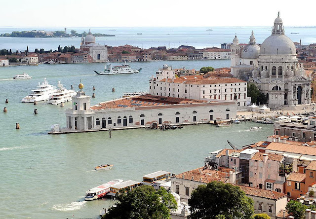
Venice From The Sky - Amazing Photos
Venice is built on 117 small islands that are separated by 150 canals. People cross the canals by many small bridges. They can also be taken for rides along the canals in a type of boat called a gondola.
The buildings in Venice are very old and attractive, and tourists come from all over the world to see them and the canals. This has made Venice one of the most famous cities in the world. The most famous sights are the Rialto Bridge, St Mark's Basilica and the Doge's Palace.
 1. Venice - one of the popular destinations of cruise itineraries. Local terminal for cruise liners every year serves up a half million passengers. (Steve Jessmore/AP Photo)
 2. Intercity transportation in Venice carried on motor boats, gondolas, barges. (Steve Jessmore/AP Photo)
 3. Venice Island - a seaside resort, the center of international tourism world-class, the venue of international film festivals, art and architecture exhibitions. (Steve Jessmore/AP Photo)
 4. Dense buildings of the historic center of Venice. (Steve Jessmore/AP Photo)
 5. Islands of the Venice lagoon, separated by 150 canals and channels, through which airlifted some 400 bridges (including the Rialto and the so-called Bridge of Sighs, both belong to the end of the XVI century). (Steve Jessmore/AP Photo)
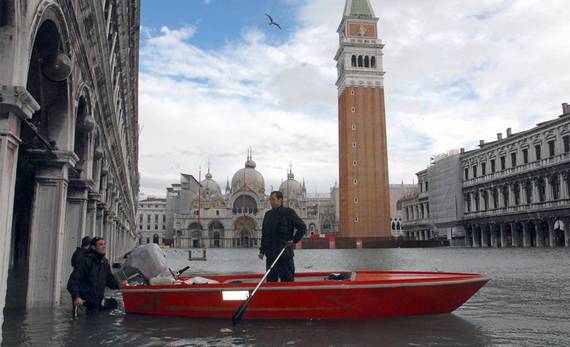
 6. Historic Downtown - Saint Mark's Square. It is the center of public life, the heart of Venice, a place of solemn ceremonies, religious and folk festivals. Now, of course, it's hard to believe that many centuries ago, there were green gardens that belonged to the nuns of nearby Benedictine monastery. (Steve Jessmore/AP Photo)
 7. The historic center of Venice is situated on 118 islands of the Venetian lagoon. (Steve Jessmore/AP Photo)
 8. At St. Mark's Square is the most ambitious building over Venice - Doge's Palace (in the lower left corner). When you look at the Doge's Palace seems that the building tilted foundation up and roof down. Central part of the facade is decorated with two richly decorated balconies. They were built to doge could appear before the people. (Steve Jessmore/AP Photo)
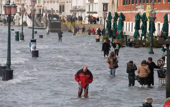
 9. Throughout the XX century Venice quickly (up to 5 mm per year) was immersed in the lagoon, as a result of land sank to 23 cm. (Steve Jessmore/AP Photo)
 11. However, we can say that Venice is living under constant threat. Water, which makes the city unique, it is both a headache. (Steve Jessmore/AP Photo)
 12. Venice is gradually disappearing under the water - this fact encountered the ancient settlers who have been forced twice to rebuild the city, going to the higher islands.
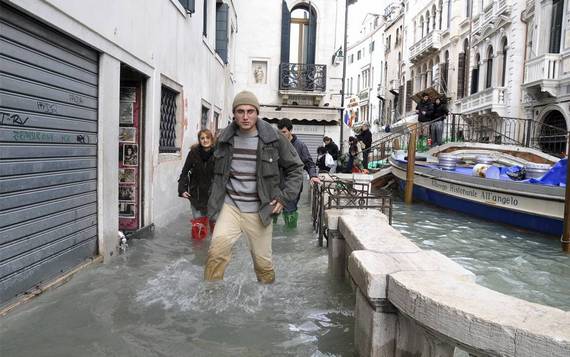
 13. Despite his romantic image of the city, attracting people from all over the world, Venice has got a very dubious list of "most smelly cities in the world." Venice has earned this title because of its far from ideal sewer system, sewage is discharged because of the hundreds of Venetian villas right in the famous canals.
 14. The main cause of distress served industrial water withdrawals from artesian wells and, consequently, the lowering of the water-bearing layer of earth; the gradual flooding of the city is also affected by increasing pressure from land-based objects: buildings, people, etc. After closing the wells of subsidence has slowed, but not ceased.
 15. However, construction of dams subjected to severe criticism because of the low efficiency of such flood protection, tested in the Netherlands, and the consequences for the environment (lack of sea water can lead to the extinction of many unique and rare species of living beings inhabiting the lagoon).
 16. To save this unique city drafted a "Moses", envisages the construction of airtight barriers around the city. The project was approved by experts and was inaugurated in 2003 with the laying of the cornerstone S. Berlusconi .
 17. Scientists have calculated that Venice could become uninhabitable as early as 2028.
The buildings in Venice are very old and attractive, and tourists come from all over the world to see them and the canals. This has made Venice one of the most famous cities in the world. The most famous sights are the Rialto Bridge, St Mark's Basilica and the Doge's Palace.


10. Those who arrived in the city on the water should see a square of St. Mark, the Doge's Palace, the Church of San Giorgio Maggiore, the Palazzo Grassi, Spanish and Italian Synagogue, walk across the bridge of Sighs, Rialto Bridge, next to the clock tower and bell tower of St. Mark , swim on the Grand Canal. (Steve Jessmore/AP Photo)


http://www.nicenfunny.com/
Most Dangerous places to live caused by Nature
 Mt Vesuvius Volcano, Campania, Italy
Mount Vesuvius is one of the world’s most dangerous volcanoes. The volcano has an eruption cycle of about 20 years, but the last eruption was in 1944. The volcano is rated as one of the most dangerous in the world with millions of people living close to the crater. In 79 AD an eruption of the volcano destroyed Pompeii and its remains are a popular tourist attraction south of Napoli. In recent years there has been an attempt to relocate some resident from the slopes of the volcano to reduce the risk from the next eruption.
 The Cold Pole, Verkhoyansk, Russia
Verkhoyansk lays claim to the title of coldest city in the world, the so-called Cold Pole. It’s hard to dispute the designation, when you consider that from September to March the city averages fewer than 5 hours of sunlight each day. (In December and January, there is nearly no sunlight.) Winter temperatures there typically fall between minus 60 and minus 40 degrees Fahrenheit. The low, recorded in the late 19th century, was minus 90. Nowadays, the city is attempting to attract “extreme tourists,” who are drawn by the intense cold. For much of its history, however, Verkhoyansk was a preferred exile destination, used first by the czars, then later by the Soviets. In the 20th century, Verkoyansk’s population peaked at 2500 residents.
 Mount Merapi, Indonesia
Even during its most tranquil periods, Mount Merapi, on the island of Java, smolders. Smoke ominously floats from its mouth, 10,000 feet in the sky. “Fire Mountain,” as its name translates to English, has erupted about 60 times in the past five centuries, most recently in 2006. Before that, a 1994 eruption sent forth a lethal cloud of scalding hot gas, which burned 60 people to death. In 1930, more than 1000 people died when Merapi spewed lava over 8 square miles around its base, the high death toll being the result of too many people living too close. In spite of this volatile history, approximately 200,000 villagers reside within 4 miles of the volcano. But Merapi is just one example of Javans tempting fate in the proximity of active volcanoes—it’s estimated that 120 million of the island’s residents live at the foot of 22 active volcanoes.
 Haiti’s Storms, Gonaïves, Haiti
First came tropical storm Fay on August 16. A week later, Hurricane Gustav blew through. Following in quick succession were Hurricanes Hanna and Ike. In the span of just one month, the coastal city of Gonaïves, one of Haiti’s five largest cities, found itself on the receiving end of four devastating tropical cyclones. When the last storm passed, Gonaïves had practically been washed out to sea. Much of the city was buried under mud, or submerged in filthy water that stood 12 feet deep in some places. The death toll ran close to 500. But the storms of August to September 2008 weren’t the most deadly in Gonaïves’ recent history. In 2004, the city of 104,000 took a severe beating from Hurricane Jeanne. Three thousand Haitians died when the Category 3 storm hit and leveled large swaths of the city. What makes Gonaïves so susceptible to destruction by hurricane? Aside from its coastal location on the Gulf of Gonâve, smack-dab in the cyclone-inclined Caribbean, Gonaïves rests on a flood plain prone to washing out when inland rivers swell. Furthermore, Haitians rely on wood to make charcoal, their primary source of fuel, and this has led to massive deforestation of the hillsides surrounding the city. As a result, when the rains come, the hills around Gonaïves melt away and mudslides nearly bury the city.
 Lake Kivu, Democratic Republic of Congo/Rwanda
Lake Kivu, located along the border between the Democratic Republic of Congo and Rwanda, is one of Africa’s Great Lakes. Deep below the surface of this lake’s 2700 square miles, there are 2.3 trillion cubic feet of methane gas, along with 60 cubic miles of carbon dioxide trapped beneath the lake under the pressure of the water and earth. If released from the depths, these gases could spread a cloud of death over the 2 million Africans who make their home in the Lake Kivu basin. The precedent for this concern stems from a pair of events that occurred in the 1980s at two other African lakes with similar chemical compositions. In 1984, 37 people died around Cameroon’s Lake Monoun in a limnic eruption. Three years later, at Lake Nyos, also in Cameroon, 80 cubic meters of CO2 were released from the water. Subsequently, 1700 people died from exposure to the toxic gas. These incidents were apparently caused by volcanic activity below the lakes, which triggered the release of the gas. Similar activity is believed to occur beneath Lake Kivu, causing many to worry that this area is next. A report from the United Nations’ Environmental Program went so far as to call the three bodies “Africa’s Killer Lakes,” and said Lake Kivu was cause for”serious concern.”
 The Ephemeral Isles, the Maldives
The Maldives are such a dangerous place that Muhammed Nasheed, upon taking office in 2008, made it one his first items of business as the Maldives’ first democratically elected president to announce a plan to create a fund for financing the relocation of the entire population. The Maldives is a confederation of 1190 islands and atolls in the Indian Ocean. Its highest point of elevation is little more than 6 feet, and, sometime in the not-too-distant future, it is likely to be swallowed whole by rising sea levels. A 2005 assessment by the United States Geological Survey, conducted after the 2004 Indian Ocean tsunami, called the Maldives one of the Earth’s youngest land masses, adding that they’re not long for life above water. According to the report, the islands “should be considered ephemeral features over geologic time.” By President Nasheed’s reckoning, the people of the Maldives would be well-served to find someplace else—India or Sri Lanka were floated as potential refuges—lest they too become ephemeral. Recent events support his decision to invest money earned through tourism in a relocation fund: The 2004 tsunami, which occurred at low tide, swept over the island, leaving 10 percent of the country uninhabitable. Of the Maldives’ 300,000 citizens, one-third were left homeless, and more than 80 people died. In 1987, during so-called “king tides,” the capital of Malé, an island city covering 1 square mile, was completely inundated. The effects of these disasters were compounded by the mining of the coral reefs that surround the islands, which has made them highly susceptible to sea erosion.
 Hurricane Capital of the World, Grand Cayman
The Cayman Islands, a British territory situated 150 miles south of Cuba, are best known as a tropical playground for the champagne and caviar set, who come to the islands for pristine Caribbean beaches, world-class diving, and lax banking regulations. Less alluring is the islands’ other reputation as “hurricane capital of the world.” According to the tropical-storm-tracking website hurricanecity.com, Grand Cayman, the largest of the three Cayman isles, is hit or brushed by at least one hurricane every 2.16 years, more than any other locale in the Atlantic basin. Since 1871, 64 storms have battered the low-lying limestone formation, often with catastrophic results. In 2004, Hurricane Ivan, a Category 5 storm with wind speeds approaching 150 miles per hour, dumped a foot of rain on Grand Cayman. A 10-foot storm surge followed, submerging a quarter of the island. An estimated 70 percent of the island’s buildings were destroyed, and its 40,000 inhabitants were left without power or clean water for days.
 The I-44 Tornado Corridor, Oklahoma City/Tulsa, Oklahoma
More than 1 million people reside along the Interstate 44 corridor that runs between Oklahoma City and Tulsa, the Sooner State’s two most populous metropolitan areas. Each spring, as the cool, dry air from the Rocky Mountains glides across the lower plains, and the warm, wet air of the Gulf Coast comes north to meet it, the residents of this precarious stretch, locally called Tornado Alley, settle in for twister season. Since 1890, more than 120 tornados have struck Oklahoma City and the surrounding area, which currently has a population of approximately 700,000. On May 3, 1999, an outbreak of 70 tornados stretched across Oklahoma, Kansas and Texas. Several of the most destructive storms swept through Oklahoma City, destroying 1700 homes and damaging another 6500. Even with modern prediction capabilities and early-warning systems, 40 people died when an F-5 twister tore through Oklahoma City. In addition to the loss of life, this display of natural devastation caused more than $1 billion in damage. Since 1950, the longest the area has gone without a tornado is five years—from 1992 to 1998. (As if making up for lost time, in the 11 months that followed that record lull, 11 tornados hit.) For only three other periods during the last half-century has Oklahoma City gone more than two years without a tornado. Northeast of Oklahoma City, along the same track that most tornado-producing storms travel, sits Tulsa, which has experienced its own share of devastation at the hands of Tornado Alley’s storms. Between 1950 and 2006, 69 tornados spun across Tulsa County—population 590,000—though none proved as deadly as the 1999 storm that hit Oklahoma City. But because of its geography—the city lies along the banks of the Arkansas River and is built atop an extensive series of creeks and their flood plains—Tulsa is particularly vulnerable to the rain that accompanies Oklahoma’s severe weather. Major floods in 1974, 1976 and 1984 caused hundreds of thousands of dollars worth of damage.

Trapped between two creeping deserts, the once fertile oasis of Minqin County, in northwest Gansu province, lives on borrowed time. The double whammy of a decade-long drought and the upriver diversion of water from its lifeline, the Shiyang River, have left Minqin to wither into the Tengger desert, which approaches from the southeast, and the Badain Jaran, closing in from the northwest. In total, since 1950, the deserts have swallowed up more than 100 square miles. During that same period, the population there has risen from 860,000 to more than 2 million. As of 2004, the deserts were approaching at a rate of 10 meters per year. With more than 130 days of wind and dust each year, that rate is unlikely to slow. Faced with rapid desertification, the Chinese government has begun relocating displaced farmers, as arable land has decreased from 360 square miles to fewer than 60.
http://www.nicenfunny.com/
Wonderful Winter Pools
1. Hotel Villa Honegg, Switzerland
 |
| link |
 |
| link |
 |
| link |
2. Cliff Lodge & Spa, Utah, USA
 |
| link |
3. Portillo Ski Resort, Chile
 |
| link |
 |
| link |
4. LeCrans Hotel & Spa, Switzerland
 |
| link |
5. The Westin Trillium House, Ontario, Canada
 |
| link |
 |
| link |
source Wonderful Winter Pools, Nice n Funny
6. Riffelalp Resort, Switzerland
In the village of Zermatt, close to the Italian border, at one of the premier ski destinations in the world, there is a resort like no other. The luxurious Riffelalp Resort is situated at 2,222 m (7,300ft) above sea level, affording guests an extraordinary and unique alpine panorama. Hit the slopes at the heart of the Gornergrat skiing district; the in-house ski concierge can assist with equipment rental and even set up heli-skiing trips. At the end of the day, soak your tired muscles in Europe's highest outdoor pool (heated to 35 degrees Celsius), taking in superb views of the Matterhorn. [link, map]
7. Hotel Chalet le Ponton, France
Chalet Le Ponton is located at the end of the Les Deux Alpes ski resort, overlooking the Veneon Valley. This pretty traditional timber-built chalet has been entirely refurbished to a high standard and has amazing views from its large terrace. On the ground floor, the spacious dining/lounge area has a internet access, comfortable sofas and French doors, which open onto a spacious south-facing terrace with sun deck and private heated pool from where to enjoy the amazing scenery. [link, map]
8. The Cambrian Hotel in Adelboden, Switzerland
Situated amid the pristine scenery of the Swiss Alps, and with stunning mountain views in every direction, The Cambrian offers the kind of location that tense desk huggers the world over spend their days dreaming about. “The Times” included The Cambrian in its list of Top 10 Outdoor Pools with amazing views worldwide. The Alpine view from this outdoor heated pool is wonderful. [link, map]
9. Montaneros Condominiums, Colorado, USA
Located steps from Vail Mountain, Montaneros offers superior 1- to 4-bedroom condominiums with exceptional guest services and amenities. Set in Lionshead Village, this quaint mountain lodge offers convenient access to Village shops, restaurants and many recreational activities. Guests who are staying at this hotel will have access to an outdoor swimming pool and hot tub. These areas are open throughout the winter months and there are pool-side changing areas for guests. [link, map]
10. Amangani Resort, Wyoming, USA
Amangani Resort in Jackson Hole, Wyoming, an exclusive member of The Haute Hotel Network, is the perfect place to vacation. The peaceful and well-known ski resort features many amenities for those who wish to stay in and have a relaxing vacation.
The resort has a 35-meter (115 ft) heated outdoor swimming pool with a 10.5-sq m (113 sq ft) whirlpool. The pool deck is the ideal place for guests to enjoy the magnificent view of the mountains and the sunset. [link, map]
11. Panorama Springs Lodge, British Colombia, Canada
These slopeside ski-in-ski-out condos afford access to Panorama Springs Hot Pools while watching skiers and snowboarders glide down the trails in this Canadian Winter Wonderland. With a cold pool, two waterslides, warm pool, splash pad, two hot tubs and sauna, the chill will be gone soon after enjoying this sprawling facility open 10 a.m. until 10 p.m. daily. [link]
12. Resort at Squaw Creek, California, USA
Squaw Valley USA features some pretty spectacular views, from Lake Tahoe to the Sierra Nevada Mountains. Home of the 1960s Winter Olympics, the winter resort is minutes north of Lake Tahoe.
Resort at Squaw Creek recently underwent a $53 million resort-wide renovation to the ski-in-ski-out property. Heated outdoor pools with waterslide pair with the resort's own ice skating rink for an unforgettable winter resort pool experience. [link, map]
 |
| link |
7. Hotel Chalet le Ponton, France
 |
| link |
8. The Cambrian Hotel in Adelboden, Switzerland
 |
| link |
9. Montaneros Condominiums, Colorado, USA
 |
| link |
10. Amangani Resort, Wyoming, USA
 |
| link |
 |
| link |
11. Panorama Springs Lodge, British Colombia, Canada
 |
| link |
12. Resort at Squaw Creek, California, USA
 |
| link |
 |
| link |
http://www.nicenfunny.com/


